The Phase 2 What We Heard Report is now available.
Thank you to everyone who participated.
About the Project
The City of St. John’s is developing a Neighbourhood Plan for the Rennie's River Neighbourhood. This plan will guide future redevelopment and improvements in the area – from the types of uses and the shape of buildings, to streets and park upgrades. Two phases of engagement are included in the planning process to ensure that the needs and desires of the people who live, work, and play there are incorporated in the Neighbourhood Plan.
The boundary of Rennie’s River generally follows Prince Philip Drive, Torbay Road, Military Road, and Bonaventure Avenue.
Draft Vision and Strategies Proposed
Phase 2 Engagement is focused on the draft vision and neighbourhood
strategies, which were developed from technical analyses and the feedback received in Phase 1. The vision reflects the overall intent for the future of the
neighbourhood. The Neighbourhood Strategy is a visual summary of the key
changes proposed for the Neighbourhood to achieve the vision.
VISION
The draft vision for Rennie's River is:
Rennie’s River will continue to be a walkable neighbourhood and an important cultural, historic, and recreational destination in St. John’s. As the neighbourhood grows, active transportation, transit, parks, and housing options will be improved to support well-being and access to everyday needs.
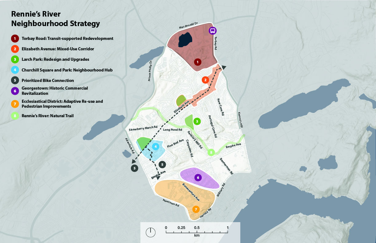
NEIGHBOURHOOD STRATEGIES
The Neighbourhood Strategies are:
- Torbay
Road: Transit-supported Redevelopment
Focus highest intensity, mixed-use growth in the existing Torbay Road and Macdonald Drive Intensification Area with integrated walking routes, and transit.
- Elizabeth
Avenue: Mixed-Use Corridor
Allow for transition over time from commercial and office to mixed-use by allowing residential uses and improving pedestrian and bike connectivity. - Larch
Park: Redesign and Upgrades
Complete a Park Master Plan and engagement for the park to identify improvements for accessibility, wayfinding, and greater all-season use. - Churchill
Square and Park: Neighbourhood Hub
Continue to support existing businesses, allow for additional mixed-use development, and formalize an outdoor community gathering space in Churchill Park. - Prioritized
Bike Connection
In alignment with the St. John’s Bike Master Plan, prioritize the completion of the bike connections that link Churchill Park to the Kelly’s Brook Shared-Use Path. - Georgestown:
Historic Commercial Revitalization
Support commercial areas that fit within the heritage context of the area. - Ecclesiastical
District: Adaptive Re-Use and Pedestrian Improvements
Support the adaption of heritage buildings for new uses that encourage tourism and community gathering and improve pedestrian experience in the area. - Rennie’s
River: Natural Trail
Update the Bike St. John’s Master Plan to remove the planned bike connection on the Rennie’s River Trail and conduct minor improvements to wayfinding and trail amenities to support pedestrian use and safety.
Quick Poll
What do you think of the key proposed neighbourhood strategies for Rennie's River?
This poll has concluded.
- Agree with all 28% (38 votes)
- Agree with most 54% (73 votes)
- Agree with some 13% (18 votes)
- Neutral 1% (2 votes)
- Disagree with some 2% (3 votes)
- Disagree with most 1% (2 votes)
- Disagree with all 0% (0 votes)
Which of the strategies do you support the most?
This poll has concluded.
- 1. Torbay Road: Transit-supported Redevelopment 10% (13 votes)
- 2. Elizabeth Avenue: Mixed-Use Corridor 13% (17 votes)
- 3. Larch Park: Redesign and Upgrades 12% (15 votes)
- 4. Churchill Square and Park: Neighbourhood Hub 17% (22 votes)
- 5. Prioritized Bike Connection 9% (11 votes)
- 6. Georgestown: Historic Commercial Revitalization 5% (7 votes)
- 7. Ecclesiastical District: Adaptive Re-Use and Pedestrian Improvements 4% (5 votes)
- 8. Rennie's River: Natural Trail 30% (39 votes)
Which of the strategies do you support the least?
This poll has concluded.
- 1. Torbay Road: Transit-supported Redevelopment 15% (24 votes)
- 2. Elizabeth Avenue: Mixed-Use Corridor 9% (14 votes)
- 3. Larch Park: Redesign and Upgrades 7% (11 votes)
- 4. Churchill Square and Park: Neighbourhood Hub 7% (11 votes)
- 5. Prioritized Bike Connection 19% (30 votes)
- 6. Georgestown: Historic Commercial Revitalization 16% (26 votes)
- 7. Ecclesiastical District: Adaptive Re-Use and Pedestrian Improvements 7% (12 votes)
- 8. Rennie's River: Natural Trail 21% (34 votes)
Ideas
Map Tool
This is now closed.
Help us plan the future of Rennie's River, Central and Mundy Pond neighbourhoods!
The City of St. John’s is creating a Neighbourhood Plan for your community. These plans will guide future redevelopment and improvements in the area – from the types of uses and the shape of buildings, to streets and park upgrades.
Provide feedback using the map tool to tell us about important places, connections, and active transportation in your neighbourhood.
This phase of engagement is open from August 26 to September 28, 2025.
The feedback we hear will help inform how future redevelopment and improvements are prioritized in the Neighbourhood Plans.
Questions
Have questions?
Check out the FAQs. Can't find what you are looking for? Post your question here and someone will get back to you as soon as possible.
To ask a question you must create an account or log in.
These are the people that are listening and responding to your questions.
The Project Team
{{question.description}}


