Check out the Cowan Heights Neighbourhood Plan
The Cowan Heights Neighbourhood Plan was presented to Council at the September 16, 2025 Committee of the Whole Meeting.
Neighbourhood Vision
Cowan Heights will be a safe, primarily residential neighborhood with a high-quality interconnected parks and pathway system at its heart. Framed by mixed-use and walkable services and amenities, the neighbourhood will provide many housing, recreation, and transportation options to support a high quality of life.
Neighbourhood Strategies:
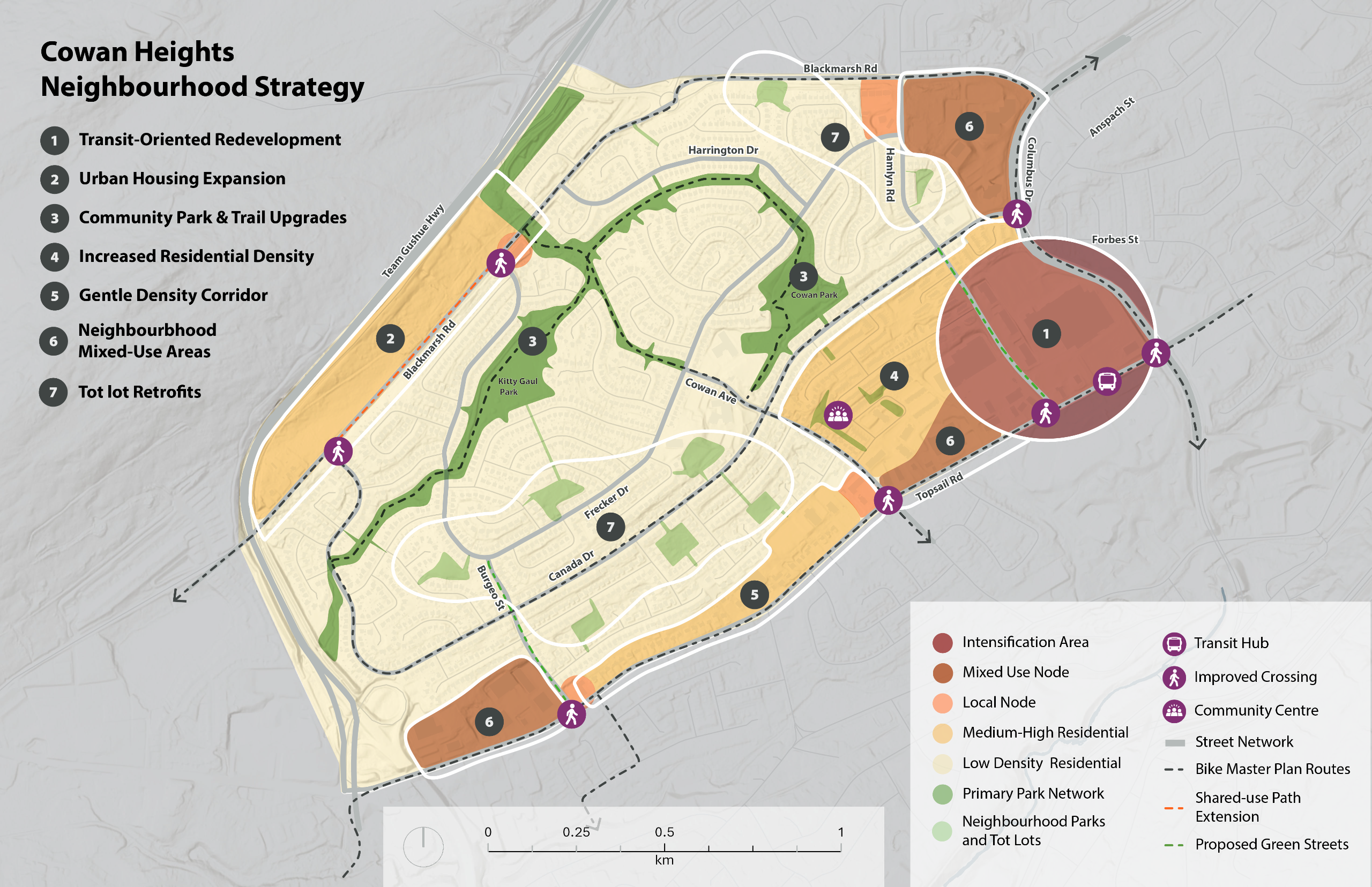
The Neighbourhood Strategy for Cowan Heights identifies seven strategies for how the neighbourhood will accommodate growth and achieve the overall vision and objectives of this Plan.
- Transit-Oriented Redevelopment: The Village Intensification Area at Topsail Road and Columbus Drive will be the focus for future higher density mixed-use development. Growth in this area will be coordinated with improvements to the existing transit hub, and pedestrian and active transportation improvements along Hamlyn and Topsail Roads and intersections. Future redevelopment will provide additional housing options and community amenities that prioritize pedestrians and provide a connection to transit and existing trail networks, benefiting existing and future Cowan Heights residents.
- Urban Housing Expansion: The areas along Blackmarsh Road are envisioned as future medium and high density residential development, supporting additional housing options for the neighbourhood. On Frecker Drive, the existing neighbourhood commercial area will remain to support residents at the north of the neighbourhood. Growth in this area will be coordinated with improvements to Blackmarsh Road, including the extension of water and sewer mains to service this area and linkages to the existing trail network.
- Community Park & Trail Upgrades: Kitty Gaul Park, Cowan Park, and the extensive connected trail network are Cowan Heights’ most beloved neighbourhood assets. The two parks will be improved to better support changing recreation needs. Trails will also be evaluated and upgraded to improve accessibility and wayfinding.
- Increased Residential Density: Land use changes to this area will allow for a transition in building height and density in housing from the high intensity Village Intensification Area and low intensity along Canada Drive. The area will support some additional medium scale apartments as well as smaller scale housing forms like townhouses and will allow for the continuation of commercial development along Topsail Road. Re-activation of the Parkside Community Centre and Barachois Park for community gathering and programming will support residents in the surrounding area and the broader neighbourhood.
- Gentle Density Corridor: This area along Topsail Road will support a gradual transition from lower density residential to more medium density forms of housing. Changes to the area will be based on market demand and require consolidation of properties over time to enable denser development. Additional housing will support the commercial areas along Topsail Road and be coordinated with active transportation improvements.
- Neighbourhood Mixed-Use Areas: Future mixed-use areas are identified at Captain Whelan Drive, Cowan Avenue, and Burgeo Street. Over time, additional housing will be supported above commercial uses in a more walkable environment.
- Tot lot Retrofits: The many smaller tot lots in Cowan Heights will be updated to provide more passive recreation and leisure opportunities for a broad range of ages and interests.
A larger version of the Neighbourhood Strategy Map can be found in the Documents section.
About the Project
The City of St. John’s is developing a Neighbourhood Plan for the community of Cowan Heights. The Neighbourhood Plan aims to take the visions we set for the City through Envision St. John's and make them real at the community/neighbourhood level. This plan will be shaped by the existing policies of the Municipal Plan, analysis of local conditions, and engagement within the neighbourhood and the wider community. To be successful, the vision and plan for Cowan Heights needs to be grounded in an understanding of the unique characteristics of the community. The plan will incorporate the needs and desires of the people who live, work, and play in these neighbourhoods.
The Cowan Heights Neighbourhood Plan will focus on the area highlighted on the map above.
This project has been made possible through funding from the Housing Accelerator Fund (HAF) provided to the City of St. John’s by the Canada Mortgage and Housing Corporation (CMHC). Learn more about how the City is using this $10.4 million in funding to stimulate housing growth at StJohns.ca.
Current Context
Cowan Heights is a neighbourhood located in the west end of St. John’s. The neighbourhood’s boundaries are the Team Gushue Highway, Blackmarsh Road, Columbus Drive and Topsail Road. The neighbourhood was originally developed in the 1970s and includes mostly single-detached homes with some commercial shops and services, including the Village Shopping Centre, on the edge along Topsail Road. Cowan Heights also features a variety of parks, two elementary schools, and a connected network of pathways.
To learn more, you can read the Background Report in the Documents section.
Other Relevant Projects
Did you know the same kind of Neighbourhood Plan project is taking place for the University Area neighbourhood? Visit the University Area project page.
Questions
Have questions?
To ask a question you must create an account or log in.
These are the people that are listening and responding to your questions.
The Project Team
{{question.description}}


