Check out the University Area Neighbourhood Plan
The University Area Neighbourhood Plan was presented to Council at the September 16, 2025 Committee of the Whole Meeting.
Neighbourhood Vision
Anchored by its rich history, institutional hub, and community spirit, the University Area will be reinforced as a unique and cherished part of the City’s urban fabric, and will become an even more connected and livable neighbourhood for all with access to jobs, diverse housing choices, education, daily needs, local and regional parks, and transportation options.
Neighbourhood Strategies
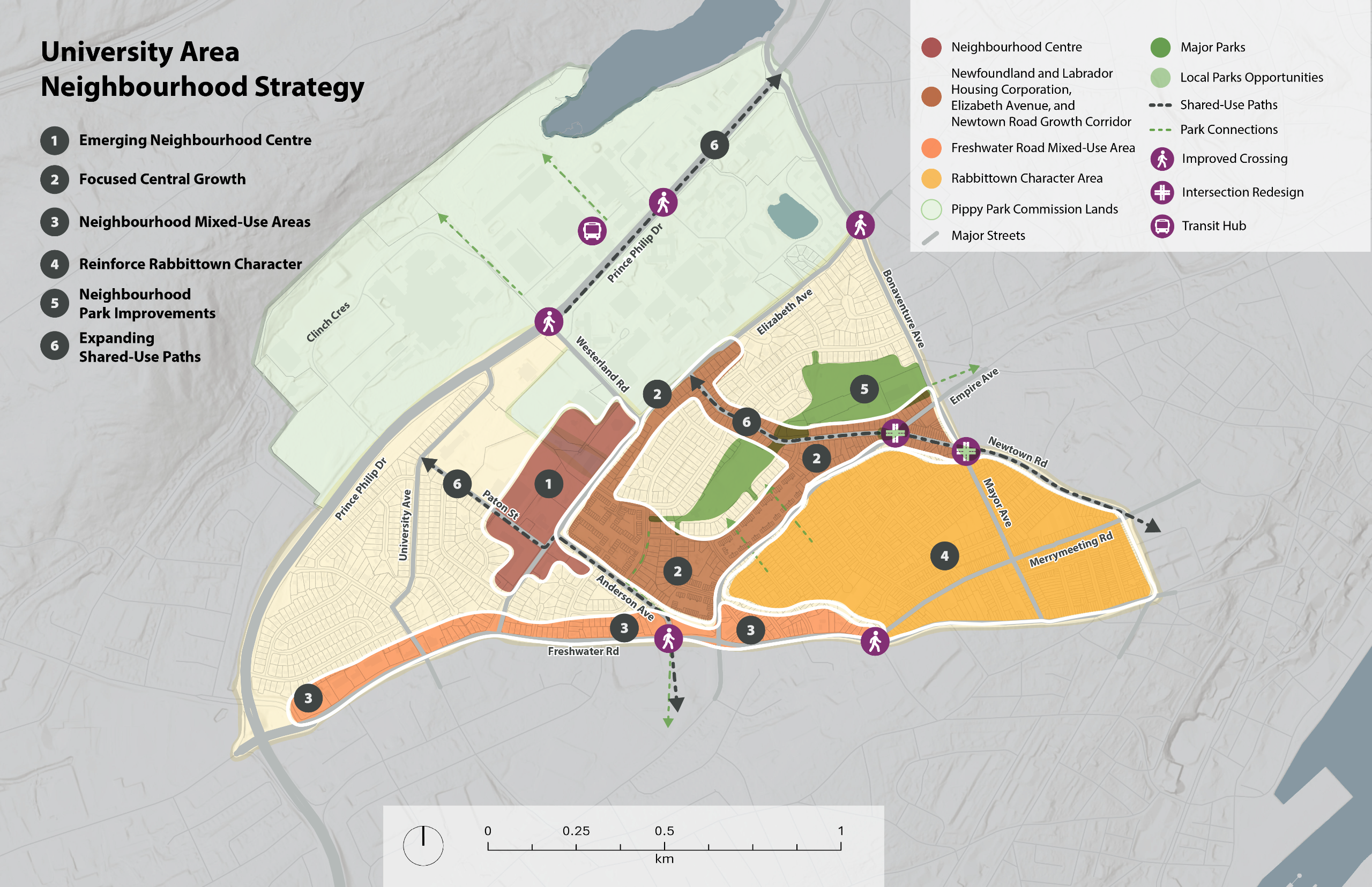
The University Area Neighbourhood Plan proposes 6 strategies to accommodate growth and achieve the vision and objectives of the Plan. The 6 strategies are:
- Emerging Neighbourhood Centre: The Paton Street, Anderson Avenue, and Elizabeth Avenue intersection is the core focus area for commercial and residential growth, and a priority area for attracting additional amenities for the neighbourhood.
- Focused Central Growth: New zoning is proposed for the Elizabeth Avenue and Newtown Road corridors to support increased densities and building heights up to four (4) storeys closest to MUN, the Neighbourhood Node, and along shared-use paths. This growth will leverage these mobility infrastructure investments while strengthening the connection to Downtown. New zoning is also proposed for properties owned by Newfoundland and Labrador Housing Corporation (NLHC). This will enable NLHC to improve their existing housing in the University Area in a manner that responds to changing demographic trends and housing demand.
- Neighbourhood Mixed-Use Areas: Highway-oriented commercial developments along Freshwater Road are encouraged to redevelop into mixed-use centres over the long-term, providing more commercial and housing choice to the neighbourhood.
- Reinforce Rabbittown Character: The Rabbittown community is home to the University Area’s oldest businesses, and this compact neighbourhood commercial character should be encouraged to expand while retaining its unique heritage.
- Neighbourhood Park Improvements: Improve connections between Rabbittown and Kelly’s Brook Park, and between the wider University Area and Pippy Park, supporting ongoing investments to enhance and activate neighbourhood parks.
- Shared-Use Paths Expansion: A series of shared-use paths will be developed in the University Area, including Newtown Road, responding to the University Area’s high number of walkers and wheelers. This will help complete a network of maintained and well-lit paths throughout the neighbourhood.
A larger version of the Neighbourhood Strategy Map can be found in the Documents section.
About the Project
The City of St. John’s is developing a Neighbourhood Plan for the University Area. The Neighbourhood Plan aims to take the visions we set for the City through Envision St. John's and make them real at the community/neighbourhood level. This plan will be shaped by the existing policies of the Municipal Plan, analysis of local conditions, and engagement within the neighbourhood and the wider community. To be successful, the vision and plan for the University Area needs to be grounded in an understanding of the unique characteristics of the community. The plan will incorporate the needs and desires of the people who live, work, and play in these neighbourhoods.
The University Area Neighbourhood Plan will focus on the area highlighted on the map above.
This project has been made possible through funding from the Housing Accelerator Fund (HAF) provided to the City of St. John’s by the Canada Mortgage and Housing Corporation (CMHC). Learn more about how the City is using this $10.4 million in funding to stimulate housing growth at StJohns.ca.
Current Context
The University Area neighbourhood is in central St. John’s. The neighbourhood is bound by Freshwater Road on the south side, Pippy Park forming most of the northwest side, and Parade Street, Newton Road, Bonaventure Avenue and Allandale Road making up the east side. Known for being the home of Memorial University of Newfoundland (MUN), the neighbourhood includes parks, schools, sports fields and the Rabbittown local community centre. The Health Sciences Centre, the largest hospital in the province, is located in the neighbourhood. Most of the area is made up of single-detached housing, except for the south side above Elizabeth Avenue which is mainly made up of campus and community facilities.
To learn more about the University Area Neighbourhood, check out the Background Report in the Documents section.
Other Relevant Projects
Did you know the same kind of Neighbourhood Plan project is taking place for the Cowan Heights neighbourhood? Visit the Cowan Heights project page.
Questions
Have questions?
To ask a question you must create an account or log in.
These are the people that are listening and responding to your questions.
The Project Team
{{question.description}}


