The Phase 2 What We Heard Report is now available.
Thank you to everyone who participated.
About the Project
The City of St. John’s is developing Neighbourhood Plans for the Central and Mundy Pond Neighbourhoods. These plans will guide future redevelopment and improvements in the area – from the types of uses and the shape of buildings, to streets and park upgrades. Two phases of engagement are included in the planning process to ensure that the needs and desires of the people who live, work, and play there are incorporated in the Neighbourhood Plans.
The Central neighbourhood’s boundary follows Freshwater Road, LeMarchant Road, Patrick Street, Water Street, Shaw Street and Cashin Avenue.
The Mundy Pond neighbourhood is centred around the physical pond and extends north to Wishingwell Park, primarily bounded by Columbus Drive, Freshwater Road, Cashin Avenue and Blackmarsh Road in St. John’s west end.
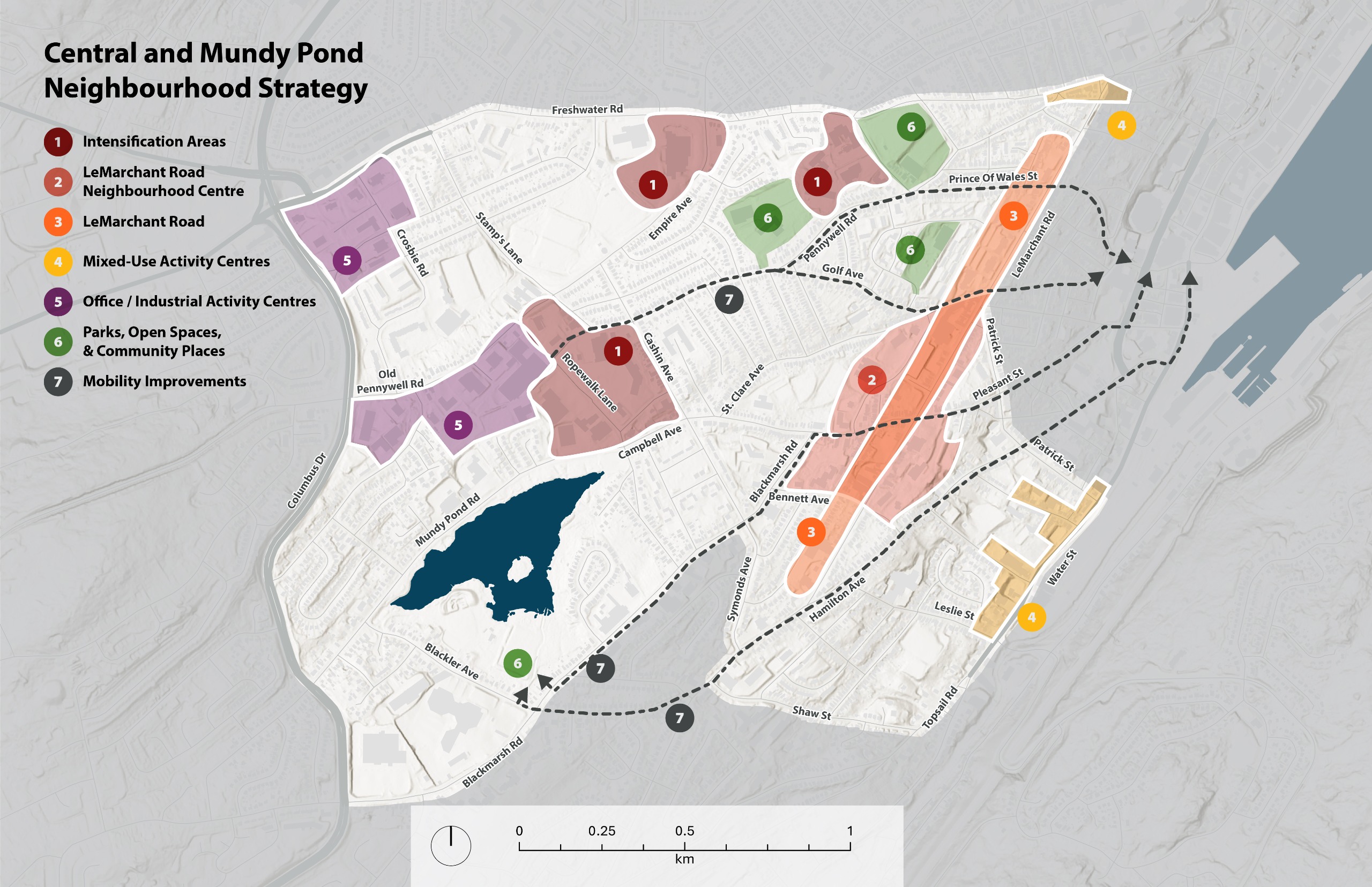
Vision and Neighbourhood Strategies Proposed
Phase 2 Engagement is focused on the draft vision and neighbourhood strategies, which were developed from technical analyses and the feedback received in Phase 1. The vision reflects the overall intent for the future of the neighbourhood. The Neighbourhood Strategy is a visual summary of the key changes proposed for the Neighbourhood to achieve the vision.
VISION
The proposed vision for the Central and Mundy Pond Neighbourhoods is:
Central and Mundy Pond are two distinct neighbourhoods that sit on a transition point between Downtown and the west end of St. John’s. These neighbourhoods are home to a diverse mix of residents who will continue to foster and enjoy the strong sense of community, access to recreation facilities, and amenities that make Central and Mundy Pond great places to call home. This area will be further improved by investments in active transportation infrastructure, housing choice, parks, trails, and other services that will positively contribute to the well-being of all residents.
NEIGHBOURHOOD STRATEGIES:
The key neighbourhood strategies are:
1. Intensification Areas: Enable more street-oriented mixed residential, commercial, and institutional redevelopment at the former Canada Revenue Agency tax centre, Ropewalk Lane, and former Booth Memorial High School site, with supporting mobility improvements.
2 & 3. LeMarchant
Road
Define
a neighbourhood centre that supports a mix of commercial, service, and
community-oriented uses while enabling supportive residential development
around this core. Support this neighbourhood centre by allowing
higher intensity mixed-use development along LeMarchant Road to help
accelerate the ongoing commercial renewal throughout Central.
5. Office/Industrial Activity Centres
6. Parks, Open Spaces, & Community Places
7. Mobility Improvements
Quick Poll
What do you think of the key proposed neighbourhood strategies for Central and Mundy Pond?
This poll has concluded.
- Agree with all 34% (23 votes)
- Agree with most 41% (28 votes)
- Agree with some 16% (11 votes)
- Neutral 3% (2 votes)
- Disagree with some 4% (3 votes)
- Disagree with most 1% (1 vote)
- Disagree with all 0% (0 votes)
Which of the strategies do you support the most?
This poll has concluded.
- 1. Intensification Areas 23% (16 votes)
- 2&3 Le Marchant Road 20% (14 votes)
- 4. Mixed-Use Activity Centre 4% (3 votes)
- 5. Office/Industrial Activity Centres 1% (1 vote)
- 6. Parks, Open Spaces, & Community Places 26% (18 votes)
- 7. Mobility Improvements 25% (17 votes)
Which of the strategies do you support the least?
This poll has concluded.
- 1. Intensification Areas 20% (15 votes)
- 2&3 Le Marchant Road 15% (11 votes)
- 4. Mixed-Use Activity Centre 11% (8 votes)
- 5. Office/Industrial Activity Centres 42% (31 votes)
- 6. Parks, Open Spaces, & Community Places 5% (4 votes)
- 7. Mobility Improvements 7% (5 votes)
Ideas
Map Tool
This is now closed.
Help us plan the future of Rennie's River, Central and Mundy Pond neighbourhoods!
The City of St. John’s is creating a Neighbourhood Plan for your community. These plans will guide future redevelopment and improvements in the area – from the types of uses and the shape of buildings, to streets and park upgrades.
Provide feedback using the map tool to tell us about important places, connections, and active transportation in your neighbourhood.
This phase of engagement is open from August 26 to September 28, 2025.
The feedback we hear will help inform how future redevelopment and improvements are prioritized in the Neighbourhood Plans.
Questions
Have questions?
Check out the FAQs. Can't find what you are looking for? Post your question here and someone will get back to you as soon as possible.
To ask a question you must create an account or log in.
These are the people that are listening and responding to your questions.
The Project Team
{{question.description}}


