
Elizabeth Avenue Shared-Use Path and Road Improvements
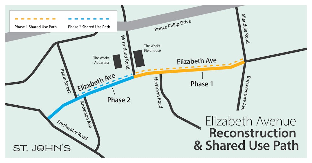
A portion of Elizabeth Avenue is being reconstructed from Bonaventure Avenue to Freshwater Road.
Upgrades from Bonaventure Avenue to Westerland Road were mostly completed in 2023 with the remaining works in this street section to be completed in early Summer 2024. Construction for 2024 will include the section from Westerland Road to Freshwater Road.
The multi-year project will be beneficial for all users of Elizabeth Avenue and includes the following improvements:
- New sidewalks and a paved shared-use path adjacent to Memorial University, extending from Bonaventure Avenue to Paton Street. The addition of a shared-use path will contribute to an active transportation network that allows people of all ages and abilities to safely get where they need to go, using whichever mode of active transportation they choose;
- A new traffic signal at the Elizabeth Avenue/Newtown Road intersection to address safety concerns and allow pedestrian crossings on all intersection approaches;
- An upgraded crosswalk and intersection at Elizabeth Avenue and Whiteway Street;
- Two new crosswalks with flashing beacons at Clark Place and near Halliday Place; and
- Improved street lighting.
Check out the detailed visuals in the document library.
The City is prioritizing projects that help create a comprehensive active transportation network and where work can be completed during planned rehabilitation and construction within other infrastructure projects. By piggy-backing on roads rehab to upgrade active transportation along Elizabeth Avenue, we will reduce overall cost and avoid future tear up (cost avoidance).
Council approved the Bike Master Plan in 2019. Its vision is to create “a safe, inclusive, and convenient cycling network that is well-connected, attractive and reflective of the City’s unique topography and climate. As part of an integrated mobility network, this is supported by policies and programs that promote a cycling friendly culture” (Bike Master Plan, 2019). The active transportation path will ultimately connect to Kelly’s Brook Shared-use Path to create an east-west cycling network.
This project was identified as an action in the City’s strategic plan, Our City, Our Future. We are committed to expanding and maintaining a safe and accessible active transportation system as we build a balanced transportation network to get people and goods where they want to go safely.
Traffic delays, detours and lane reductions will be required while work is ongoing. The City of St. John’s will provide updates on traffic interruptions and progress throughout the duration of the project. You can review the project schedule on this page to follow progress for this project and subscribe to receive the latest City news and advisories.
Construction Projects in the Memorial University Area
A significant amount of work is being completed in the Memorial University area during the 2024 construction season, which will impact the overall flow of traffic in the area. In addition to the above, the following projects will also be active in the area:
Have a question or want to make a comment?
Check out the FAQs, can't find your answer there, pop us a question.
-
Share will the Elizabeth Ave shared path for this phase end this week? on Facebook Share will the Elizabeth Ave shared path for this phase end this week? on Twitter Share will the Elizabeth Ave shared path for this phase end this week? on Linkedin Email will the Elizabeth Ave shared path for this phase end this week? link
will the Elizabeth Ave shared path for this phase end this week?
Liza-Ann Tucker asked over 1 year agoWe apologize for the delay. The detour will be removed Friday, Dec. 22 and work will conclude for the season. There will be some site work to complete in the spring, but details will be shared about that at that time.
-
Share When will Elizabeth Ave be reopened for traffic near the university? The project schedule says November 2023 but it's already near the end of December 2023 and you still can't get to the university using Elizabeth Ave. on Facebook Share When will Elizabeth Ave be reopened for traffic near the university? The project schedule says November 2023 but it's already near the end of December 2023 and you still can't get to the university using Elizabeth Ave. on Twitter Share When will Elizabeth Ave be reopened for traffic near the university? The project schedule says November 2023 but it's already near the end of December 2023 and you still can't get to the university using Elizabeth Ave. on Linkedin Email When will Elizabeth Ave be reopened for traffic near the university? The project schedule says November 2023 but it's already near the end of December 2023 and you still can't get to the university using Elizabeth Ave. link
When will Elizabeth Ave be reopened for traffic near the university? The project schedule says November 2023 but it's already near the end of December 2023 and you still can't get to the university using Elizabeth Ave.
Emilg asked over 1 year agoWe apologize for the delay. The detour will be removed Friday, Dec. 22 and work will conclude for the season. There will be some site work to complete in the spring, but details will be shared about that at that time.
-
Share How long is the construction going to last? on Facebook Share How long is the construction going to last? on Twitter Share How long is the construction going to last? on Linkedin Email How long is the construction going to last? link
How long is the construction going to last?
Fardeen Munshi asked over 1 year agoThe phase currently underway will be substantially completed in Nov. of this year with surface asphalt paving completed in June 2024. The second phase - Westerland Rd. to Freshwater Rd. - will begin in 2024. You can follow the project schedule on the project page.
schedule ,timelinesschedule timelines -
Share Nice to see a separated bike path. I cycle to MUN for work and I know many other people do as well. It will be nice to have a dedicated multi-use path. However, unless it is linked up to a broader network of bike paths, it is not that helpful. Right now, I tend to got off Elizabeth at Allandale and travel on the interior university roads, which do not have much traffic. This project would be great if there was a cycle lane along the entirety of Elizabeth Avenue. It will be awkward leaving the university heading east, because you will have to dismount at Allandale Road and cross Elizabeth to get back on the right side of the road. As such, it is a bit of a mystery to me how the multi-use path will ever be integrated with a cycling lane network (unless a lane is sacrificed on Elizabeth Avenue for a two-way cycling lane on the north side of the street). Anyways, I will appreciate the 90 second or so that I actually get to cycle on a separated bike path on the way to work. Hopefully a network can be built outward over time. I know most people in St. John's are pretty anti-bicycle, but I urge people to give it a try. It feels so good getting exercise as you move from point A to B. on Facebook Share Nice to see a separated bike path. I cycle to MUN for work and I know many other people do as well. It will be nice to have a dedicated multi-use path. However, unless it is linked up to a broader network of bike paths, it is not that helpful. Right now, I tend to got off Elizabeth at Allandale and travel on the interior university roads, which do not have much traffic. This project would be great if there was a cycle lane along the entirety of Elizabeth Avenue. It will be awkward leaving the university heading east, because you will have to dismount at Allandale Road and cross Elizabeth to get back on the right side of the road. As such, it is a bit of a mystery to me how the multi-use path will ever be integrated with a cycling lane network (unless a lane is sacrificed on Elizabeth Avenue for a two-way cycling lane on the north side of the street). Anyways, I will appreciate the 90 second or so that I actually get to cycle on a separated bike path on the way to work. Hopefully a network can be built outward over time. I know most people in St. John's are pretty anti-bicycle, but I urge people to give it a try. It feels so good getting exercise as you move from point A to B. on Twitter Share Nice to see a separated bike path. I cycle to MUN for work and I know many other people do as well. It will be nice to have a dedicated multi-use path. However, unless it is linked up to a broader network of bike paths, it is not that helpful. Right now, I tend to got off Elizabeth at Allandale and travel on the interior university roads, which do not have much traffic. This project would be great if there was a cycle lane along the entirety of Elizabeth Avenue. It will be awkward leaving the university heading east, because you will have to dismount at Allandale Road and cross Elizabeth to get back on the right side of the road. As such, it is a bit of a mystery to me how the multi-use path will ever be integrated with a cycling lane network (unless a lane is sacrificed on Elizabeth Avenue for a two-way cycling lane on the north side of the street). Anyways, I will appreciate the 90 second or so that I actually get to cycle on a separated bike path on the way to work. Hopefully a network can be built outward over time. I know most people in St. John's are pretty anti-bicycle, but I urge people to give it a try. It feels so good getting exercise as you move from point A to B. on Linkedin Email Nice to see a separated bike path. I cycle to MUN for work and I know many other people do as well. It will be nice to have a dedicated multi-use path. However, unless it is linked up to a broader network of bike paths, it is not that helpful. Right now, I tend to got off Elizabeth at Allandale and travel on the interior university roads, which do not have much traffic. This project would be great if there was a cycle lane along the entirety of Elizabeth Avenue. It will be awkward leaving the university heading east, because you will have to dismount at Allandale Road and cross Elizabeth to get back on the right side of the road. As such, it is a bit of a mystery to me how the multi-use path will ever be integrated with a cycling lane network (unless a lane is sacrificed on Elizabeth Avenue for a two-way cycling lane on the north side of the street). Anyways, I will appreciate the 90 second or so that I actually get to cycle on a separated bike path on the way to work. Hopefully a network can be built outward over time. I know most people in St. John's are pretty anti-bicycle, but I urge people to give it a try. It feels so good getting exercise as you move from point A to B. link
Nice to see a separated bike path. I cycle to MUN for work and I know many other people do as well. It will be nice to have a dedicated multi-use path. However, unless it is linked up to a broader network of bike paths, it is not that helpful. Right now, I tend to got off Elizabeth at Allandale and travel on the interior university roads, which do not have much traffic. This project would be great if there was a cycle lane along the entirety of Elizabeth Avenue. It will be awkward leaving the university heading east, because you will have to dismount at Allandale Road and cross Elizabeth to get back on the right side of the road. As such, it is a bit of a mystery to me how the multi-use path will ever be integrated with a cycling lane network (unless a lane is sacrificed on Elizabeth Avenue for a two-way cycling lane on the north side of the street). Anyways, I will appreciate the 90 second or so that I actually get to cycle on a separated bike path on the way to work. Hopefully a network can be built outward over time. I know most people in St. John's are pretty anti-bicycle, but I urge people to give it a try. It feels so good getting exercise as you move from point A to B.
John Sandlos asked over 1 year agoThanks for the feedback. A plan for a full cycling network is outlined in the Bike St John’s Master Plan (2019). The current construction on Elizabeth Ave. is a project from this plan where we are piggy-backing on road work that was scheduled. Wherever possible, when there is rehabilitation work needed on a street, we are including shard use paths identified within the cycling plan, to avoid future tear ups.
There are roughly 15 kms of new shared-use paths funded for construction in the next few years. You can check out the full list of projects underway on the City Website. With these new paths, in addition to the 24 kms of existing bike routes in the city, the goal is to create a network of connected and comfortable routes for people to cycle. Extending the bike route east along Elizabeth Avenue is in the plan but hasn’t been funded yet.
elizabeth ave east bikeselizabeth ave east bikes -
Share I have a MUN parking permit for lot 1A (on the south side of campus); the entrance to this lot (divided into three parts) is from Elizabeth Avenue, on the east side of the Arts and Admin Building, and the exit is on the west side of the Arts and Admin Building. My question: will this lot and the entrance and exit remain available during construction? on Facebook Share I have a MUN parking permit for lot 1A (on the south side of campus); the entrance to this lot (divided into three parts) is from Elizabeth Avenue, on the east side of the Arts and Admin Building, and the exit is on the west side of the Arts and Admin Building. My question: will this lot and the entrance and exit remain available during construction? on Twitter Share I have a MUN parking permit for lot 1A (on the south side of campus); the entrance to this lot (divided into three parts) is from Elizabeth Avenue, on the east side of the Arts and Admin Building, and the exit is on the west side of the Arts and Admin Building. My question: will this lot and the entrance and exit remain available during construction? on Linkedin Email I have a MUN parking permit for lot 1A (on the south side of campus); the entrance to this lot (divided into three parts) is from Elizabeth Avenue, on the east side of the Arts and Admin Building, and the exit is on the west side of the Arts and Admin Building. My question: will this lot and the entrance and exit remain available during construction? link
I have a MUN parking permit for lot 1A (on the south side of campus); the entrance to this lot (divided into three parts) is from Elizabeth Avenue, on the east side of the Arts and Admin Building, and the exit is on the west side of the Arts and Admin Building. My question: will this lot and the entrance and exit remain available during construction?
schipper1947 asked over 1 year agoAccess to MUN parking lots 1, 1A,and 2 will be maintained throughout construction and are included in the local access only portion of the road detour.
detour,local traffic,parking lots mundetour local traffic parking lots mun -
Share How will drivers exiting the university onto Elizabeth Avenue in front of the the Arts & Administration Building (exit between Halliday Place and Newtown Road be accommodated? There is no alternative exit for drivers using the parking lots 1A, 2 and 1. on Facebook Share How will drivers exiting the university onto Elizabeth Avenue in front of the the Arts & Administration Building (exit between Halliday Place and Newtown Road be accommodated? There is no alternative exit for drivers using the parking lots 1A, 2 and 1. on Twitter Share How will drivers exiting the university onto Elizabeth Avenue in front of the the Arts & Administration Building (exit between Halliday Place and Newtown Road be accommodated? There is no alternative exit for drivers using the parking lots 1A, 2 and 1. on Linkedin Email How will drivers exiting the university onto Elizabeth Avenue in front of the the Arts & Administration Building (exit between Halliday Place and Newtown Road be accommodated? There is no alternative exit for drivers using the parking lots 1A, 2 and 1. link
How will drivers exiting the university onto Elizabeth Avenue in front of the the Arts & Administration Building (exit between Halliday Place and Newtown Road be accommodated? There is no alternative exit for drivers using the parking lots 1A, 2 and 1.
Lynnkanwal asked over 1 year agoAccess to MUN parking lots 1, 1A,and 2 will be maintained throughout construction and are included in the local access only portion of the road detour.
local traffic,access to mun,parking lotslocal traffic access to mun parking lots -
Share Please continue to add more bike infrastructure to the city. It is much appreciated and improves the livability of St. John's immensely. on Facebook Share Please continue to add more bike infrastructure to the city. It is much appreciated and improves the livability of St. John's immensely. on Twitter Share Please continue to add more bike infrastructure to the city. It is much appreciated and improves the livability of St. John's immensely. on Linkedin Email Please continue to add more bike infrastructure to the city. It is much appreciated and improves the livability of St. John's immensely. link
Please continue to add more bike infrastructure to the city. It is much appreciated and improves the livability of St. John's immensely.
dan asked over 1 year agoThanks for the feedback. The City has a strategic goal to expand and maintain a safe and accessible active transportation network as outlined in our Strategic Plan. You can track progress of initiatives on the website and through quarterly updates to Council. A full listing of all active transportation work in progress this year can be found on the city's website.
-
Share What is the proposed lane width, it's hard to see but it appears the lane widths are still quite wide - has consideration been given to narrowing lanes to assist in slowing traffic allowing the creation of a separated protected bikeway instead of a MUP or using the additional space gained to preserve the trees? on Facebook Share What is the proposed lane width, it's hard to see but it appears the lane widths are still quite wide - has consideration been given to narrowing lanes to assist in slowing traffic allowing the creation of a separated protected bikeway instead of a MUP or using the additional space gained to preserve the trees? on Twitter Share What is the proposed lane width, it's hard to see but it appears the lane widths are still quite wide - has consideration been given to narrowing lanes to assist in slowing traffic allowing the creation of a separated protected bikeway instead of a MUP or using the additional space gained to preserve the trees? on Linkedin Email What is the proposed lane width, it's hard to see but it appears the lane widths are still quite wide - has consideration been given to narrowing lanes to assist in slowing traffic allowing the creation of a separated protected bikeway instead of a MUP or using the additional space gained to preserve the trees? link
What is the proposed lane width, it's hard to see but it appears the lane widths are still quite wide - has consideration been given to narrowing lanes to assist in slowing traffic allowing the creation of a separated protected bikeway instead of a MUP or using the additional space gained to preserve the trees?
imstillkp asked almost 2 years agoLane widths have been narrowed as much as possible while still supporting transit along Elizabeth Avenue. The shared-use path is separated from motor-vehicle travel lanes by a landscaped boulevard.
-
Share Is there a plan to increase the amount of places where I could park my bike? I think this is a great step forward but at the moment I'm very limited in the places I can go and safely store my bike when I'm not using it. My understanding of shared use paths are that they are both for pedestrians and people using personal vehicles (bikes, scooters, etc.), is there a plan in place to help make pedestrians more comfortable walking around people using these vehicles? on Facebook Share Is there a plan to increase the amount of places where I could park my bike? I think this is a great step forward but at the moment I'm very limited in the places I can go and safely store my bike when I'm not using it. My understanding of shared use paths are that they are both for pedestrians and people using personal vehicles (bikes, scooters, etc.), is there a plan in place to help make pedestrians more comfortable walking around people using these vehicles? on Twitter Share Is there a plan to increase the amount of places where I could park my bike? I think this is a great step forward but at the moment I'm very limited in the places I can go and safely store my bike when I'm not using it. My understanding of shared use paths are that they are both for pedestrians and people using personal vehicles (bikes, scooters, etc.), is there a plan in place to help make pedestrians more comfortable walking around people using these vehicles? on Linkedin Email Is there a plan to increase the amount of places where I could park my bike? I think this is a great step forward but at the moment I'm very limited in the places I can go and safely store my bike when I'm not using it. My understanding of shared use paths are that they are both for pedestrians and people using personal vehicles (bikes, scooters, etc.), is there a plan in place to help make pedestrians more comfortable walking around people using these vehicles? link
Is there a plan to increase the amount of places where I could park my bike? I think this is a great step forward but at the moment I'm very limited in the places I can go and safely store my bike when I'm not using it. My understanding of shared use paths are that they are both for pedestrians and people using personal vehicles (bikes, scooters, etc.), is there a plan in place to help make pedestrians more comfortable walking around people using these vehicles?
Timothy asked almost 2 years agoThe city installed bike racks downtown in 2022 and has plans to expand bike rack installations in the future when funding allows. Shared-use paths are meant to be used by all modes of active transportation. To ensure a positive experience for everyone on the shared-use paths, we're taking steps to promote courteous behavior. Clear signs will remind users to stay on the right, yield to pedestrians, and use signals when passing. The paths will also be wide enough to accommodate various speeds, allowing for safe passing.
bike racksbike racks -
Share Why is it being built on Facebook Share Why is it being built on Twitter Share Why is it being built on Linkedin Email Why is it being built link
Why is it being built
Cloveless79 asked over 1 year agoThe shared-use path on Elizabeth Avenue is a result of several plans, programs, and events. In 2016 the MUN Traffic Study identified a shared-use path for this street. In 2019 the Bike Master Plan included Elizabeth Avenue as a link on the planned bike network. Given the age and condition of the street, it is scheduled for rehabilitation as part of the city’s regular maintenance program. Finally, the project is being built in time for the 2025 Canada Games and is funded by a partnership of all 3 levels of government.
Follow Project
Project Schedule
-
Detailed Design
Elizabeth Avenue Shared-Use Path and Road Improvements has finished this stageDetailed design work completed for Phase 1 in June 2023, and for Phase 2 in March 2024.
-
Tender Call - Phase 1 - Bonaventure Ave to Westerland Rd
Elizabeth Avenue Shared-Use Path and Road Improvements has finished this stageTender call for Phase 1 - Bonaventure Avenue to Westerland Road. Scheduled closing July 4, 2023.
-
Phase 1 Construction - Bonaventure Ave to Westerland Rd
Elizabeth Avenue Shared-Use Path and Road Improvements has finished this stagePhase 1 Construction - Bonaventure Ave to Westerland Road, will begin August 2023 and will be active until November 2023. With surface asphalt paving being completed in summer 2024.
-
Tender Call - Phase 2 - Westerland Road to Freshwater Rd
Elizabeth Avenue Shared-Use Path and Road Improvements has finished this stageTender call for Phase 2 - Westerland Road to Freshwater Road. Scheduled closing April 3, 2024.
-
Phase 1 Construction Completion
Elizabeth Avenue Shared-Use Path and Road Improvements has finished this stagePhase 1 Construction anticipated to be completed August 2024.
-
Phase 2 Construction - Westerland Road to Freshwater Road
Elizabeth Avenue Shared-Use Path and Road Improvements is currently at this stageConstruction from May 2024 to November 2024. Surface asphalt to be placed in spring 2025.
-
Phase 2 Construction Completion
this is an upcoming stage for Elizabeth Avenue Shared-Use Path and Road Improvements
Frequently Asked Questions (FAQs)
- What is the Elizabeth Avenue Road Reconstruction and Shared Use Path project?
- What are the hours of work?
- Why can't the City do the work at night?
- Why does each phase of the project take a full construction season to complete?
- Will traffic be impacted?
- Will there be access to local residences and businesses?
- How will I know if there are any traffic or other interruptions?
- What about the Metrobus bus stops at Elizabeth Avenue?
- What is the project funding source?
Document Library
-
 Elizabeth Avenue Shared Use Path and Road Improvements Visual (251 KB) (jpg)
-
ELIZABETH AVE RECONSTRUCTION & SUP - PHASE 1 - BONAVENTURE AVE TO WESTERLAND ROAD.pdf (15.7 MB) (pdf)
-
ELIZABETH AVE RECONSTRUCTION & SUP - PHASE 2 - WESTERLAND ROAD TO FRESHWATER ROAD.pdf (10.6 MB) (pdf)
-
Phase 2 - Drawings L101-L108 and L201-L208 - 03-25-2024.pdf (5.12 MB) (pdf)
-
Phase 1 Detour Map - Effective August 18, 2023.pdf (1.25 MB) (pdf)
-
Phase 1 Detour Map - Effective Nov 6, 2023.pdf (96.6 KB) (pdf)

Who do I need to contact about this project?
-
MG
Phone (709) 576-3171 Email mgale@stjohns.ca -
SH
Phone 576-8045 Email shickman@stjohns.ca
Thank you for your contribution!
Help us reach out to more people in the community
Share this with family and friends